How to Use Aerial Maps for Turkey Scouting Online
It might feel like turkey season is still a long ways off, but it’s getting closer every day. Before you know it, you’ll be sitting in the woods again listening for that old tom calling in the distance. But you might as well use the time you have now to better prepare for opening day. No, that doesn’t mean you have to travel and spend your weekends scouting for turkeys just yet. You can get a lot done just by turkey scouting online. By planning ahead, you can make a list of areas you want to hunt, make field scouting easier (and more accurate), save time, and improve your odds. Want to learn how?
Benefits of Aerial Maps for Scouting
If you don’t already use aerial maps for scouting hunting areas – whether it’s for turkeys, whitetails, or other wild game animals – you’re missing out on a huge advantage. Even for private property that you know like the back of your hand, it helps to study aerial maps so you can make connections between different hunting areas. You can use these maps to find good locations to put your ground blinds, or mark some areas where you can study the turkey activity using trail cameras. Essentially, it focuses your actual field scouting time down to only the best-looking or highest priority areas. Here are some of the advantages of using aerial maps for turkey scouting online.
· Easy – unsurprisingly, you can scout for turkeys online from the comfort of your home. You don’t need to go tromping through the woods or fields in the late winter (when the scouting might not be that helpful anyway). You can grab a beverage, sit back on your couch in your sweat pants, and scout for turkeys. Who doesn’t want to do that?
· Cover Lots of Area – you can quickly cover multiple large properties when you’re desktop scouting for turkeys. There’s no need to walk it all – just scroll and click to see the habitat features across the entire parcel in a fraction of the time it would take you to scout in-person.
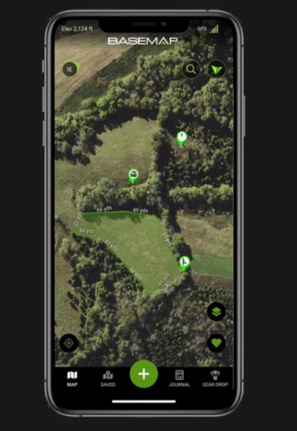
· Measuring Tools – by turkey scouting online, you can easily measure distances between objects or areas of interest. For example, if you see some potential roost trees, you can measure the distance between them and your access route or ground blind location, so you know you’re not getting too close. You might be able to rule out some areas using this technique.
· Bird’s Eye View – unless you have a drone with a camera, you’re not going to see your hunting area from a bird’s eye view. But when you use aerial maps, which are usually available in very high definition, you can see how all the habitats are laid out on your property, and map out some potential turkey travel corridors. You may even be able to see your hunting area in a 3D format, which really makes the landscape pop out in detail.
3 Features to Look for Turkeys
As you’re studying your aerial maps for turkey scouting online, there are a few things you should look for to get the most out of your effort. These habitat features are things that you can expect to attract or funnel toms in the spring. Later in the brood-rearing season and on into the fall and winter, these key habitat features may change a bit, but the following are important ones to turkeys in the spring breeding season.
1. Roost Trees – Some western sub-species can thrive without a lot of forest cover, but most still do perch somewhere at night. The Eastern sub-species relies heavily on some kind of woodland cover. They use trees to roost in at night for safety and may occasionally do so during the day too. An ideal roost tree should be a mature tree with lots of horizontal/lateral branches, which make it easier for the turkeys to perch on. Mature oaks, pines, and cottonwoods can provide this type of structure. On an aerial map, look for large canopy areas, especially when adjacent to some kind of opening or field – this offers the turkeys a clear flight path in and out of the tree. If there are plenty of large trees nearby other woodland cover and openings, it would be safe to assume there are some turkeys in this area.
2. Food/Foraging Areas – Another key habitat feature for turkeys is some kind of feeding area. This can vary a lot throughout the year and from property to property, but there are some good examples for spring turkey hunting scenarios. Often, turkeys will scratch around in farm fields or food plots in the spring, looking for waste grain, weed seeds, new plant shoots, and insects. They will also use the next habitat feature for feeding (see more below). Both can be seen on aerial maps very easily. Eastern turkeys generally prefer smaller openings where there’s ample cover nearby. So if you see multiple small feeding areas in close proximity, there are likely turkeys in the area that will work through these spaces.
3. Openings – Openings are often some of the first places to find green plants growing in the spring. As a result, there can be a lot of overlap with openings and food sources (e.g., new plant growth, seeds, or insects). But turkeys also these openings for strutting. Hens will often come out into these openings to feed, and toms will use them as their strut zones to attract the hens. Trails, log landings, and forest openings/clearcuts can all provide this kind of cover too. On aerial maps, smaller ATV trails in heavy forest cover can be hard to see, but old landings, timber cuts, meadows, and food plots will show up well. If you see some larger woodland areas connected to fields and openings with trails, this would be a good spot to follow up on with in-person scouting.
What’s the Best Turkey Scouting Tool?
So what’s the easiest way to do all of this turkey scouting online? You could get by with online maps, which usually have decent aerial imagery. But if you want to have the most streamlined experience that can integrate field observations, the BaseMap™ app is our go-to choice. You can use this platform from either a mobile device or your computer, so you have a lot of flexibility when scouting. Where available,
the 3D maps really make it easier to see how your property is laid out and how turkeys might move across it. You can turn on different layers to make it more informative or less cluttered, or drop pins where you want to check things out in more detail (e.g., such as a potential ground blind location).
Using BaseMap in the field makes it even more accurate. When you follow up your online turkey scouting with field scouting, you can take pictures, which the app saves in the appropriate location. Each observation is catalogued with the BaseMap SmartMarkers, which record basic weather conditions, such as temperature, wind speed/direction, and barometric pressure. Overall, it’s a great scouting tool that will really help you when planning your spring turkey hunt.

